Pleasant Valley—once the unassuming hinge of the lower Tulpehocken between State Hill and Mt. Pleasant—was a compact hamlet where farm met factory, canal met country road, and a mill’s hum blended with wagon-shop rhythms. For more than a century it held together the traffic of the valley; by the late 1970s it lay mostly under the waterline and margins of Blue Marsh Lake. What endures are footpaths that trace old lanes, stone foundations that surface during winter drawdowns, and the powerful memory carried in photographs, artifacts, and the stories of people who worked and lived there.
Explore an interactive map that plots every known property taken and razed for the Blue Marsh Lake Project, overlaid on a 1958 Penn Pilot aerial. Click or tap pin by pin to see where homes, farms, churches, and crossroads once stood—then compare them to today’s shoreline and recreation areas by changing the transparency.
Pleasant Valley—once the unassuming hinge of the lower Tulpehocken between State Hill and Mt. Pleasant—was a compact hamlet where farm met factory, canal met country road, and a mill’s hum blended with wagon-shop rhythms. For more than a century it held together the traffic of the valley; by the late 1970s it lay mostly under the waterline and margins of Blue Marsh Lake. What endures are footpaths that trace old lanes, stone foundations that surface during winter drawdowns, and the powerful memory carried in photographs, artifacts, and the stories of people who worked and lived there.
It grew without a charter along the Union Canal, the 1828 waterway joining the Susquehanna and the Schuylkill. Here the prism and towpath hugged the Tulpehocken’s inside bends. Lock 41 stood just west of the Pleasant Valley Inn; Locks 42 and 43 stepped the water level near the Pleasant Valley Roller Mill and the approach to Blue Marsh Bridge. Warehouses, a toll house, and canal-side businesses stitched the place into a regional flow of flour, feed, timber, coal, and farm goods—an unincorporated town that nonetheless moved with the commerce of a small port.
Industry anchored the creek. The earliest mill on the Pleasant Valley site is locally attributed to Gabriel Hiester—its sandstone date stone read as 1742, the name “Huster” reflecting German spelling. Jonathan Hiester rebuilt in 1838–39, and by the 1890s the works had become a modern roller mill. Ownership cycled through Kerschner, Reber, Miller, Fry, Richardson, and the Bechtel brothers, Frank and Edwin. Edwin purchased the property in 1927 and christened it the Pleasant Valley Roller Mill; his son-in-law, Gordon Weidenhammer, joined in 1941, and the Weidenhammers took over in 1945. After damage to the dam and race in 1946, water power yielded to electricity. The mill turned out White Rose flour and, later, feed and dog food. Acquired for the dam project, the building was salvaged, but a May 1977 fire erased what demolition hadn’t.
Down Gruber Road from the Wagon Works stood a long-serving inn. Early on it was kept by the Stamm family; by 1915 it traded as Eyrich’s Pleasant Valley House and in mid-century doubled as a summer venue for dances and clam bakes. On February 28, 1902 floodwaters climbed fourteen inches in the barroom—an omen of a watery fate. Like so much else, it disappeared in the clearances for the lake.
William Penn Tavern (William Penn Hotel). At the southeast corner of Gruber Road and Route 183, another landmark welcomed travelers: a three-and-a-half-story fieldstone tavern raised around 1830, its finely cut walls and steep gables projecting quiet authority over Penn Township’s crossroads. The main façade, balanced by evenly spaced sash windows and deep-hued shutters, faced the road; inside, broad plank floors creaked toward a generous stone fireplace that anchored the public room. Known variously as the William Penn Tavern and the William Penn Hotel, it offered meals, beds, and a long polished bar that became part of the community’s social fabric—its whereabouts now a small local mystery. The original painted signboard, preserved by the Gruber family, survives today at the Landis Valley Village & Farm Museum. Ownership passed from the Grubers to Arthur Kreitler and then to the William Kreitler family, each era layering its own memories on the stone. In 1976 the tavern fell to the Blue Marsh project; where it stood, the lake and its margins now keep watch. In memory, though, the doorway still opens and the rooms still ring with voices.

William Penn Tavern

William Penn Tavern & Gruber Wagon Works
The 1887 Pleasant Valley Bridge carried the Tulpehocken crossing from Penn Township into North Heidelberg at the foot of Tulpehocken Road, a western counterpart to Blue Marsh Bridge downstream. Its date stone—naming county commissioners D. G. Keller, S. K. Fisher, and J. L. Wagner; contractors Hawman Bros.; and engineer A. H. Tyson—marked Berks County’s iron age. The truss and its stone piers vanished beneath Blue Marsh, though abutment fragments and pier bases still emerge at low pool.
If the mill ground the valley’s grain, the Gruber Wagon Works put Pleasant Valley on wheels. Franklin H. Gruber raised the three-story factory in 1882 on Licking Creek at the foot of Mt. Pleasant: “Pleasant Valley” on the signboards, “Obold” at the post office. At its height, twenty men mass-produced painted box wagons and hay flats for a broad farm market. Power evolved from water wheel to steam to gasoline to electric, and in 1905 a cable-hung elevator hoisted finished wagons to the paint shop. Production peaked in the 1920s; the last new wagon rolled out in 1956, and repairs continued until 1972.

Gruber Wagon Works
Blue Marsh took the site but not the shop. In December 1976 the factory was cut into four massive sections—the largest 86 tons—and inched five miles to the Berks County Heritage Center. There, after some 19,000 tools and parts were cataloged and reinstalled exactly as found, the Gruber Wagon Works reopened as a National Historic Landmark: the most complete surviving example of a rural wagon manufactory in the United States.
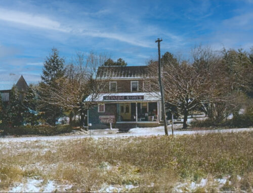
Pleasant Valley was also a lived-in landscape. Near the junction of Gruber and Old State roads stood the Pleasant Valley School, a two-room (one up, one down) structure erected around 1900. Its little stage hosted plays and ice-cream festivals; classes ended in 1931. The Marsh Union Sunday School met there, and its bell now rings at Green Valley Elementary. Along Gruber Road, homes lined the slope—the Grubers’ own house; the Eliza and Isaac Stamm residences; Billie Gruber’s place; the Schlappich home—descending toward the valley where Gruber’s bridged Licking Creek and the old Bernville Road curved into Mt. Pleasant. On the edge of nearby Blue Marsh village, Pyle’s Keystone Store doubled as a general store and garden nursery, a favorite stop for penny candy, groceries, and spring flowers.

Pyle’s Keystone Store
Echoes of laughter—hayrides at the Schlappich farm. Raymond (“Pop”) and Carrie Schlappich purchased their Pleasant Valley acreage in the late 1930s, raising eggs and produce for neighbors while their son George grew up a farm kid on the creek. “Pop” had a gift for gathering people: he’d hitch a team to the wagon, lay down fresh straw, and wave aboard a jostling crowd of neighborhood children. George, older than most, helped keep order and watch for little hands and feet. Summer rides rolled past wild phlox and Virginia bluebells along the water, the wagon sometimes ambling on toward the “83 Creamee” for sundaes. At dusk the mood shifted—couples tucked under blankets, stars pricked the ridge, and a bonfire snapped back at the dark. “Pop” always kept extra marshmallows for George, but George mostly worked—toting wood and tending the flames, listening to laughter, stories, and the stray harmonica tune slide across the night air. When the Blue Marsh Dam Project loomed, the joy dimmed. Officials warned the family not to improve buildings—they wouldn’t be compensated for upgrades once the property was taken. George helped his parents auction what they couldn’t carry away, rooms emptying piece by piece. “It was hard,” he said later. “It was a hard time for us.” Today the Schlappich house site lies where old Route 183 once ran; aside from the memory, little remains.

Schlappich Farm
Summer bungalows dotted the Tulpehocken’s banks at Pleasant Valley and the Palisades, drawing Reading families for weekends of fishing, canoeing, and porch-front camaraderie. When Hurricane Agnes struck in June 1972, those light cabins—some planted directly atop the old canal prism—filled to the windowsills. Many never came back.
Expropriation arrived in stages. After years of studies and hearings—and a long pause between authorization in 1962 and construction in 1974—the U.S. Army Corps of Engineers and the Commonwealth of Pennsylvania acquired the valley. Some owners first sold outer parcels to the state under Project 70; later the Corps purchased the flood pool and recreation lands. Certain buildings were salvaged; others were auctioned for stripping. Abandonment brought vandalism and fires. The roads shifted like a spilled maze: Route 183 was lifted and realigned between Mt. Pleasant and Bernville; Church Road rose and bent; Palisades Road found a new connection; Snyder School Road and low reaches of Old State Road slipped under water. The iron bridges—Speicher (1878), Pleasant Valley (1887), and Blue Marsh (1909)—went from weight-limited to water-logged to gone. In their place came a dam 1,775 feet long and 98 feet high, an emergency spillway cut into the southern ridge, and a control tower blending releases for flood control and water quality. The dam was dedicated in June 1978; in July 1979 some 35,000 people jammed the roads for the recreation area’s opening.

Speicher Bridge

Speicher Bridge
Not everything was lost. The Gruber Wagon Works was saved to the Heritage Center; the Deppen family cemetery was re-interred nearby; and entire log buildings from surrounding farms were re-erected at Old Dry Road Farm, an eighteenth-century German complex now interpreted along Brownsville Road. What time and fire removed included the shell of the Pleasant Valley Roller Mill (burned in 1977), the inn, scores of canal structures and farmsteads, the already fire-damaged Blue Marsh Hotel, and strings of summer bungalows. Winter’s low pool still reveals the stone outlines of Lamm’s Mill on Spring Creek, the bases of old bridge piers, the ghost trace of Water Road skirting the creek, and cut-off tree rows where porches once looked down on the “Tully.”

Pleasant Valley Roller Mill
For those who called it home, Pleasant Valley was more than a dot on a map; it was a rhythm—millstones and planers, school bells and Saturday dances, wagon wheels and canal horns. Its traces persist in the striped gears and hay flats at Gruber’s, the log ends and springhouses at Old Dry Road Farm, the linear meadows of the old Union Canal, and in names that linger on signposts: Gruber, Pleasant Valley, Palisades, State Hill. Walk the lakeside trails that follow the old alignments; pause in the big frame shop at the Heritage Center; stand at the dam overlook where the Tulpehocken once bent around the mill. If you listen, you can still hear the place: a vanished heart of the Tulpehocken that, by being lost, taught Berks County what to save—and how to tell the rest.

Leave A Comment